Washington Hikes
My very first summer in Washington did not disappoint. Most weekends Emma and I headed east into the Cascades and were able to get quite a few day hikes under our belts. We picked all of our hikes from the Washington Trails Association website which has an awesome Hike Finder Map where we could find hikes based on level of difficulty and length.
Mason Lake via Ira Spring Trail
LENGTH | 6.5 miles / 10.5 km
ELEVATION GAIN | 2420 ft / 738 m
TIME FROM SEATTLE | 1 hour
This was our first hike of the summer and I got my first glimpse of Mt Rainer!! Go during wildflower season- in late June we still saw a ton of flowers starting to come out. I’d probably recommend doing this in combination with Bandera Mountain, which shares the trailhead and first half of the climb up. The lake wasn’t the most beautiful alpine lake I saw this summer but the views on our way up made it a very scenic hike. Get in early to get parking and bring bug spray because the flies are relentless at the lake!
Lake 22
LENGTH | 5.4 miles / 8.7 km
ELEVATION GAIN | 1350 ft / 411 m
TIME FROM SEATTLE | 1 hour 15 min
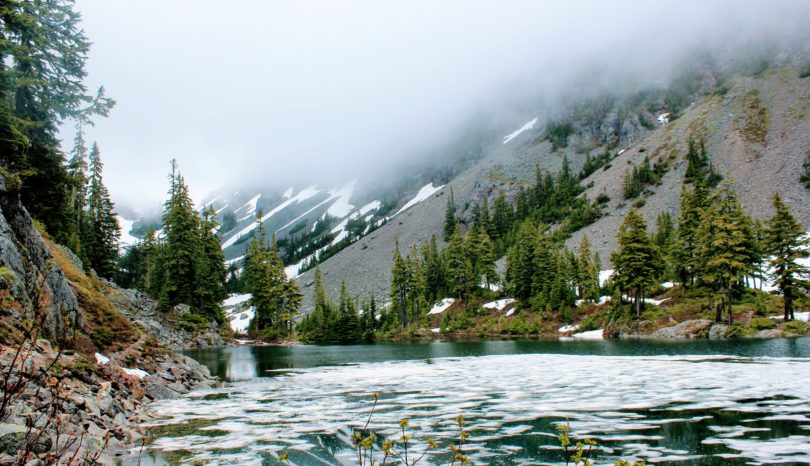
Our first hike with Chester, Emma’s aunt’s golden doodle!! This hike wasn’t very difficult but it’s still a bit of a climb. We basically ran up the mountain to keep up with Chester. The lake was gorgeous and there was still a ton of snow around it in late June. Wear hiking boots because the trail was pretty muddy. We didn’t get a parking spot in the lot but we did manage to score one in a second lot a bit further down the road.
Granite Mountain
LENGTH | 8.6 miles / 13.8 km
ELEVATION GAIN | 3800 ft / 1158 m
TIME FROM SEATTLE | 45 min
The distance and elevation gain are a bit intimidating, but the trail itself isn’t crazy steep. The inclines are fairly gentle and there are plenty of switchbacks. The trail was really nice but it seemed never ending!! We thought we were almost at the top when we were only about halfway. Save this hike for later in the summer because the last bit of the trail to the top was snowed in when we went in early July. To get around the snow there was a bit of a rock scramble that required a bit of bouldering. It began to rain during our ascent so we opted to turn around to save ourselves from climbing down slippery rocks. The rain and clouds blocked the view from us but we did catch glimpses of the mountains and we were surrounded by wildflowers!
Melakwa Lake
LENGTH | 8.5 miles / 13.7 km
ELEVATION GAIN | 2500 ft / 762 m
TIME FROM SEATTLE | 1 hour
Our second hike with Chester! We went on a pretty rainy day so we had to go through a lot of mud and stream crossings- we didn’t make it out dry or clean so bring your most water proof shoes. All things considered, this hike was good for a rainy day because we still got a magical view of the lake! There was a decent amount of snow on the trail but things were still pretty well marked.
Rattlesnake Ledge
LENGTH | 4 miles / 6.4 km
ELEVATION GAIN | 1160 ft / 354 m
TIME FROM SEATTLE | 30 minutes
Rattlesnake Ledge is apparently one of the more popular hikes in the area; we went on a weekday and the top was still swarming with hikers. Go on a weekday or go early if you don’t want to deal with the crowds. The hike is understandably popular because the view is spectacular for a relatively easy hike! We brought Emma’s dog, Ginger, and a friend’s dog, Cola, with us and both small dogs could manage the way up and down. Bring a bathing suit to take advantage of the lake at the trailhead!!
Iron Goat Trail
LENGTH | 6 miles / 9.7 km
ELEVATION GAIN | 700 ft / 213 m
TIME FROM SEATTLE | 1 hour 45 min
This hike is a bit further out but it’s a non strenuous hike with lots of scenery so it’s well worth the drive. The trail is about 3 miles of flat pathway that used to be a railroad. There are tons of informational signs and you can see tunnels that were built through the mountains. For a better look at the valley, there’s a short trail that goes up in elevation to a lookout point. There’s a trail that goes around and makes the hike a loop but we found the trail to be covered with stinging nettles so we came back down and hiked the flat portion out and back. This trail also had stinging nettles along the sides as well as a lot of bugs so come prepared with long pants and bug spray.
McClellan Butte
LENGTH | 9 miles / 14.5 km
ELEVATION GAIN | 3700 ft / 1128 m
TIME FROM SEATTLE | 45 min
McClellan Butte was definitely one of the more challenging hikes we tackled this summer. The incline is pretty steady and the trail rarely levels out for the whole 4.5 miles up. We went on a rainy day so we skipped the rock climb to get to the actual summit but still found a nice spot to sit and enjoy the view as the clouds rolled through the valley. I have so many regrets about not bringing a container to collect huckleberries along the trail. Our hike was considerably slower because we kept pulling over to snack.


